A river is the most visible way the land moves. Rain that falls on a hillside does not stay there: it gathers, accelerates, and begins to carve. Over a human lifetime a river seems fixed; over a million years the same channel can shift a continent. This reading explains the machinery — how a drainage basin stores and releases water, how a river spends its energy, how it erodes and deposits, and how the patterns it leaves behind record the rocks beneath them. The thread running through every section is the same: water moving downhill carries energy, spends it on the land, and leaves behind a shape that encodes the balance of forces at work.
1. The Drainage Basin as a System
A drainage basin (or catchment) is the area of land that contributes water to a single river and its tributaries. Its outer edge is the watershed (or divide) — the ridge line where a drop of rain falling on one side flows to one river, and a drop on the other side flows to another. Within the basin, small streams join larger ones at confluences, and the whole network drains to a single mouth where the river enters the sea, a lake, or an inland sink. Basins nest inside one another: the basin of a small tributary is a sub-basin of the larger river's basin, and every point on a channel has its own catchment upstream of it.
A drainage basin behaves like a system with inputs, stores, and outputs. The input is precipitation (P). Some of it is lost back to the atmosphere as evapotranspiration (E) — the sum of evaporation from soil and water surfaces plus transpiration from plants. The remainder becomes runoff (Q) that travels through the channel. The balance is closed by changes in storage (ΔS) held in soil moisture, groundwater, snow, ice, and surface ponds:
P = Q + E ± ΔS
If storage is steady from one year to the next, precipitation equals the sum of runoff and evapotranspiration. In a wet season storage fills (ΔS positive) and runoff is low relative to rainfall; in a dry season storage empties (ΔS negative) and runoff is sustained by what was stored. The equation is the same for a single storm and for a whole year; only the time step changes. The equation is also a statement of accounting rather than of mechanism: it says the books must balance, but not how quickly each transfer happens. Two basins with identical annual totals can behave completely differently week to week, because one routes water through deep groundwater and the other sends it straight down the surface.
A worked example makes the arithmetic concrete. Suppose a basin receives 1,000 mm of precipitation in a year, loses 400 mm to evapotranspiration, and discharges 650 mm as runoff. The books do not balance, so storage must have fallen by 50 mm over the year (1,000 = 650 + 400 − 50, with ΔS = −50). That 50 mm was drawn from groundwater and soil moisture, and if the deficit persists across several dry years the water table drops, springs weaken, and baseflow declines even though the rainfall total looks unchanged. Reverse the sign — suppose runoff is only 500 mm while evaporation holds at 400 mm — and storage must have gained 100 mm, refilling the aquifer. Over a long period ΔS must average out to near zero, because storage cannot rise or fall forever; the basin would either flood or dry up. This constraint is why a century of records tends to converge on a stable relationship between rainfall, evaporation, and runoff, even though any single year can deviate sharply.
Not all rain reaches the channel immediately. Water that lands on vegetation may evaporate or drip to the ground; water on the ground may infiltrate into soil until the soil is saturated, after which excess becomes overland flow. Below the surface, water moves slowly downward by percolation into the water table and sideways as throughflow within the soil, feeding the river between storms as baseflow. The rapid component added during a storm is stormflow (or quickflow). The split between these two — how much rain arrives quickly versus how much is delayed and smoothed — is governed by vegetation (interception), soil permeability, slope, and how much of the basin is paved or compacted. A forest may intercept a fifth of a rainfall and let most of the rest infiltrate; a city of roofs and roads sends the same storm straight to the channel.
The sequence of events during a storm is worth following step by step, because each step changes the next. Rain first wets the leaves and the ground surface, and this initial water is largely lost to interception and evaporation — the basin is "paying its bills" before any reaches the channel. Then infiltration begins, filling the soil pores; while the soil has spare capacity, almost all the water soaks in and very little reaches the surface. Only once the soil is saturated, or once the rain falls faster than the soil can absorb it, does a film of overland flow develop and begin to sweep downhill. This threshold behaviour explains why a long gentle drizzle may produce no flood while a short violent downpour on the same ground produces a flash flood: what matters is not the total rainfall but whether the intensity outruns the soil's ability to absorb it.
The regime of a river is its pattern of discharge through the year. A snow-fed river in a cold region peaks in late spring when snow melts, even if rainfall is low then. A monsoon-fed river peaks in the wet season. A river crossing many climate zones averages them out. Basin shape matters too: a long, thin basin delivers storm runoff gradually, because water from its far end takes longer to arrive, while a round, compact basin concentrates it, because every part of the basin is roughly the same distance from the outlet. Size matters as well — a large basin integrates many storms and therefore varies less than a small one, whose whole area may lie under a single rain cloud. Geology shapes the regime from below: a basin floored by permeable limestone or sandstone retains water and releases it slowly, whereas a basin underlain by impermeable clay or granite sheds it almost immediately.
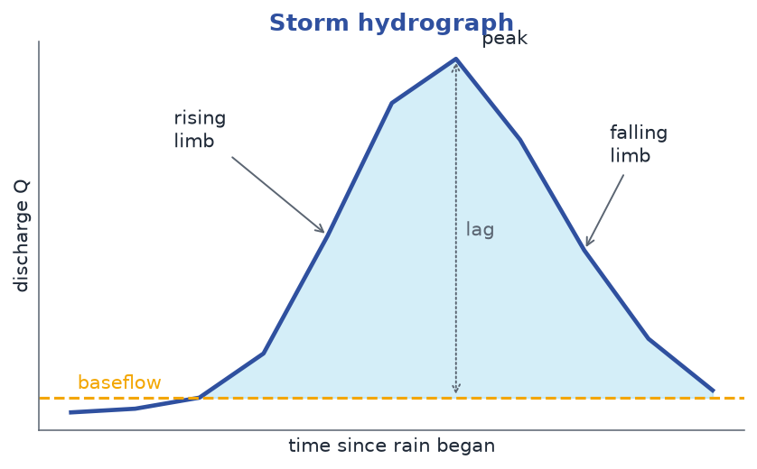
The storm hydrograph is the record of discharge at a point during and after a single rain event. It has a rising limb as water arrives, a peak (the maximum discharge), a lag time between the rain and that peak, and a falling limb as the basin drains back toward baseflow. A short lag time and a sharp peak mean a fast, flashy response — typical of steep, urbanised, or impervious basins. A long lag time and a rounded peak mean a sluggish, buffered response — typical of vegetated, permeable, or large basins. Urbanisation shifts the whole curve: it shortens lag time, raises the peak, and sharpens the limb, because paving removes the infiltration and storage that once delayed the flow. The shape of the hydrograph is therefore a summary of everything the basin does with water, and reading it is how hydrologists diagnose how a catchment behaves.
2. The Long Profile and Energy
If you plot a river's height above sea level against its distance from the source, you get its long profile. Almost every river draws a curve that is steep near the source and flattens downstream — a concave-up profile. The headwaters plunge down mountain slopes; the lowland reach drifts almost level to the sea. The shape is not an accident: as a river grows it gains water and widens and deepens its channel, so it can carry the same load at a gentler gradient. A young, small stream needs a steep slope to move its bedload; a mature, large river can do the same work on a near-flat one. In effect the river trades slope for size, and the concave curve is the record of that trade all the way to the sea.
The concept of base level sits underneath the profile. Base level is the lowest point to which a river can erode — usually sea level, but sometimes a lake or a resistant rock bar that the river cannot cut through. A graded river is one whose profile is smoothly adjusted to its load and discharge so that, over time, it neither builds up nor cuts down along most of its length; it simply carries what it is given. When base level falls (the sea retreats, or the land rises), the river has renewed energy to cut downward, and a wave of incision moves upstream from the mouth. When base level rises, the river deposits and its lower reaches back up with sediment. A sharp break in the smooth profile — a knickpoint, often marked by a waterfall or rapid — records where the adjustment has not yet finished, and such breaks tend to migrate slowly upstream as the river erodes back into them.
A river is a machine for converting potential energy into motion. A parcel of water at height z holds potential energy mgz (mass × gravity × height). As it descends, that energy becomes kinetic and is spent on friction, on dragging its load, and on wearing the bed. The rate at which a river does this work is its stream power:
Ω = ρ g Q S
where ρ is water density, g is gravity, Q is discharge (volume per second), and S is the channel slope. Dividing by channel width w gives specific stream power ω = ρ g Q S / w — the erosive force per metre of bed. A steep, high-discharge mountain river has enormous specific stream power and is a fierce eroder; a low, lazy lowland river has little and mostly transports what it is given. The two forces in the formula pull in opposite directions along a river's length: discharge Q rises downstream as tributaries add water, but slope S falls, and in most rivers the fall in slope more than cancels the rise in discharge, so specific stream power peaks in the middle course. This is why mountain rivers cut and mountain gorges form upstream, while lowland rivers build and meander near the mouth — the energy budget, not the distance, decides which process wins.
A simple numerical sketch shows how sensitive the budget is. Doubling the discharge of a river while holding slope and width constant doubles its stream power, but doubling its width halves the specific stream power, because the same force is spread over twice the bed. Because slope enters as a multiplier, a river that steepens from 0.001 to 0.002 doubles its power without any change in flow. This is why a flood that both deepens the channel and steepens the local gradient can suddenly do years of erosion in a few hours, and why a single boulder or a fallen tree that concentrates the flow into a narrow chute can carve a pothole far faster than the surrounding bed.
Discharge itself is the product of the channel's cross-section and speed:
Q = w · d · v
width × depth × mean velocity. Two rivers with the same discharge can look entirely different — one narrow and fast, one wide and slow — because width, depth, and velocity adjust to the available slope and the material of the bed. This set of adjustments is called hydraulic geometry: as you move downstream, width, depth, and (more slowly) velocity all tend to increase, while slope decreases. Width grows fastest of the three, so a river doubles its width before it doubles its depth, and its velocity changes least of all. The practical result is that a big river is mostly bigger across, not faster; the gentle lowland river in the plain may be no swifter than the mountain stream it grew from. Velocity is the master variable: it sets how large a particle a river can pick up and how much it can carry.
Within a single cross-section, velocity is not uniform either. It is fastest at the surface and in the middle of the channel, and slowest at the bed and banks, where friction with the boundary drags on the flow. The line of fastest flow is the thalweg, and it swings from side to side as the channel bends — which is exactly why the outer bank of a bend is scoured and the inner bank is built. A smooth, well-rounded channel with little friction has a nearly uniform velocity across its width; a rough, boulder-strewn one has a velocity that changes sharply from point to point, so its flow is uneven and full of eddies.
Where a river crosses a band of resistant rock it cannot easily erode, the softer rock downstream is worn away faster, and the resistant band is left standing as a step in the profile — a waterfall or rapid. The falling water has enormous power at its base, where the vertical drop is converted into a plunge pool; eddies there swirl stones round and round, grinding cylindrical hollows called potholes into the bed. Given time, the plunge pool undermines the resistant band from below, blocks of rock fall away, and the waterfall retreats upstream, leaving a steep-sided gorge in its wake. This is the mechanism by which a knickpoint migrates: the fall is not a permanent feature but a moving front, and the gorge below it is the trench it has already cut.
Competence is the largest particle a flow can move; it rises steeply with velocity (roughly with a high power in many formulations, so a modest speed-up lets a river shift boulders instead of sand). Capacity is the total volume of load a river can transport; it grows with discharge and velocity. The two are easily confused but behave differently: competence is about the biggest grain, capacity is about the total amount. A river can have high competence but low capacity — it can move a few large stones but not much total material — or low competence but high capacity, moving a great volume of fine silt that it could never lift a boulder from. When velocity falls, competence drops first and the biggest particles drop out; capacity falls too and the river sheds the rest, so the deposit left behind is sorted, with the coarsest material dropped nearest the source of the slowdown.
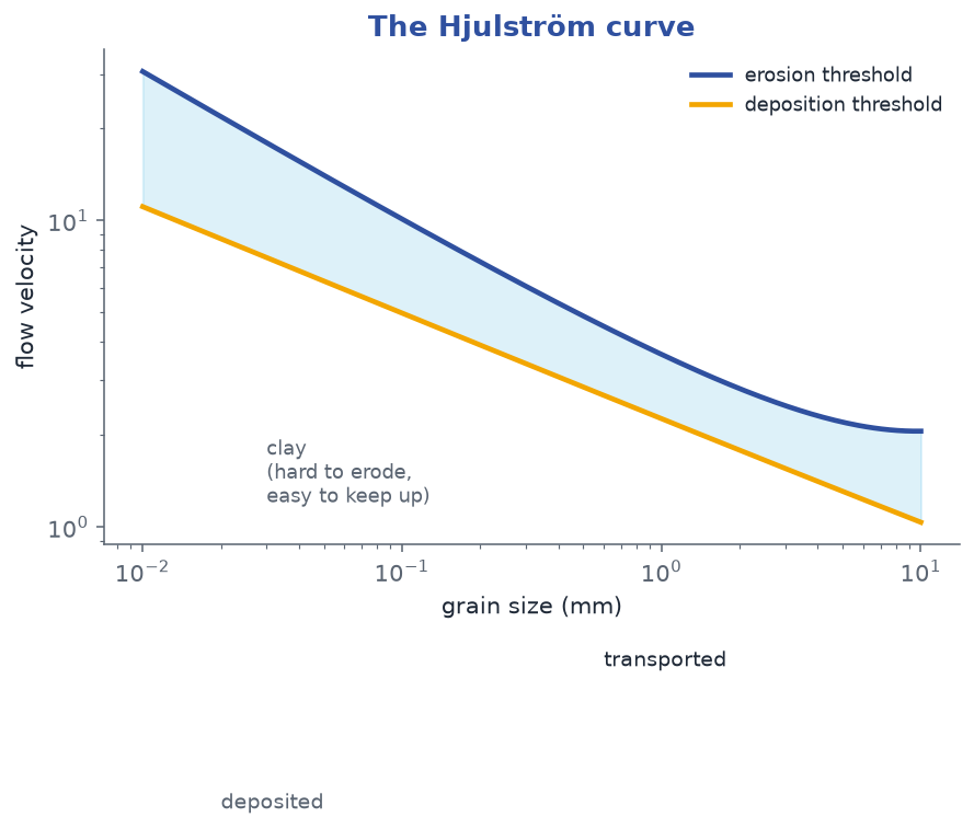
The relationship between flow speed and grain size is captured by the Hjulström curve (Figure 2). For sands and gravels there is a U-shaped threshold: a grain must be hit by a certain velocity to be eroded, a slightly lower velocity will keep it in transport, and a still lower velocity lets it deposit. The curve is highest for the medium sands, which need the strongest flow to be set in motion, and lowest for fine gravels, which are heavy enough to resist but small enough to be caught by the flow. The curious part is the finest material: clays and silts are easy to keep suspended once stirred up, but surprisingly hard to erode from the bed, because cohesive mud sticks together. So there is a band of low velocities where clay is neither eroded nor deposited — it simply sits. This is why a slowly flowing muddy river can carry almost nothing new yet stay opaque: the particles already in suspension stay up, but the bank does not give up more. The curve also explains a counter-intuitive field observation: a river that has just flooded and is now falling can deposit a layer of fine silt on the floodplain even though it is still moving fast enough to be visibly muddy, because it has dropped below the erosion threshold for the mud while remaining above the settling threshold for the sand.
3. Erosion, Transport, Deposition
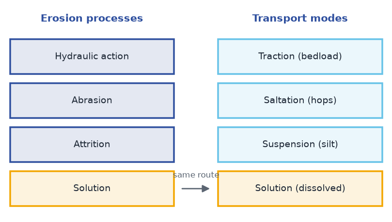
A river erodes its bed and banks in four distinct ways, and the four are not interchangeable — each dominates in a different setting. Hydraulic action is the sheer force of moving water, including air and water compressed into cracks that prises rock apart; it is strongest where flow is fast and turbulent, and it is what undermines a bank during a flood. Abrasion (or corrasion) is the grinding of the bed by the load the river carries — the single most powerful eroder, since hard particles act like sandpaper and can deepen a gorge faster than any chemical process. Attrition is what happens to the load itself: particles bump and grind against each other, growing rounder and smaller as they travel, which is why river gravel is rounded while freshly broken rock is angular. Solution (or corrosion) is the chemical dissolving of soluble rock — limestone and chalk beds lose mass invisibly to the flow, contributing a dissolved load that no sieve can catch. A single reach usually experiences all four at once, but in different proportions; a bedrock gorge in hard granite is dominated by abrasion and hydraulic action, while a channel cut through limestone loses much of its mass to solution.
Once a particle is free, the river moves it by four routes according to size. The largest fragments roll or slide along the bottom as bedload by traction; many of these hop in a stuttering bounce called saltation. Fine silts and clays are lifted into the water column and carried in suspension, often for hundreds of kilometres — a grain of fine silt stirred up in the headwaters may not settle until it reaches a lake or the sea. The dissolved load — ions from solution — is invisible and travels everywhere the water goes. Together these make the river's load, and the split between them shifts constantly with velocity: speed up and the suspended fraction balloons; slow down and bedload drops first. Generally the suspended and dissolved fractions dominate the total mass a large river carries, while the visible bedload is a small but geomorphologically crucial part. The reason the invisible fractions dominate is scale: finer material is far more abundant at the surface than boulders are beneath it, and once it is in suspension it costs the river almost no energy to keep it moving.
The four transport modes are not fixed categories but positions on a continuum that any given grain moves along as the flow changes. A pebble may sit motionless on the bed during low flow, be nudged into a roll as the current picks up, bounce in saltation through a riffle, and finally come to rest again in a pool behind a boulder. The same grain can experience all four modes in the course of a single flood. This is why the bed of a river is never static even when the water looks calm: every rise and fall of discharge reshuffles which grains move and how far, and the record left in the deposit is a history of many such events rather than a single snapshot.
Deposition is simply the reverse: when velocity falls below what a particle needs to stay moving, it settles. This happens wherever the river loses energy — on the inside of a bend, where the gradient eases, where a channel widens and shallows, behind an obstacle, or at the mouth where the current meets still water. Because deposition is controlled by energy loss rather than by distance, the same river can erode in one place and build in another at the same moment: a falling boulder may be plucked from an upland bed and dropped on a coastal plain in the same journey. Deposition also sorts material by size: the coarsest gravel is dropped first where the flow first slows, sand next, and the finest silt and clay are carried farthest and settle last, which is why a delta that stretches into the sea is made of the finest material the river could still hold. The result over time is a landscape in which the size of the sediment tells you how far the water had slowed, and therefore how far it had travelled from the source.
The balance between erosion and deposition shifts along the river's length and with the seasons. In the upper course, where slope is steep and power is high, erosion generally outruns deposition and the channel cuts down. In the middle and lower course the gradient eases, power falls, and deposition gains the upper hand, so the river builds rather than cuts. Seasonally, the same reach may scour during a winter flood and fill during a summer low flow, so a channel that looks permanent is in fact inching back and forth around a long-term average. It is that average, not any single flood, that sculpts the valley over geological time.
4. Meanders and Floodplains
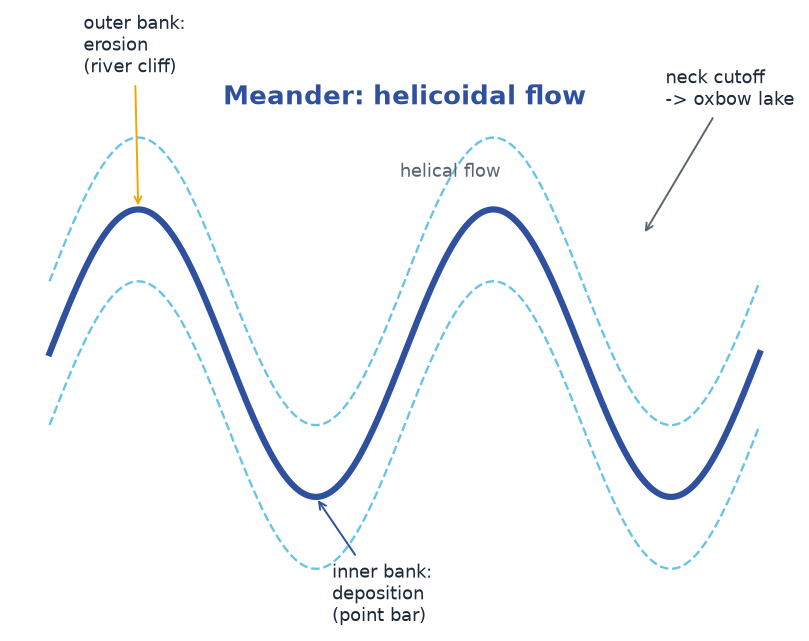
In the middle and lower course the gradient is gentle and the river no longer has the energy to cut downward; instead it erodes sideways. The channel develops bends called meanders. The engine of a meander is helicoidal (helical) flow: water on the surface is pushed by the bend's centrifugal effect toward the outer bank, sinks there, and returns along the bed toward the inner bank. This corkscrew motion concentrates fast, deep, erosive flow on the outside of the bend and slow, shallow, depositional flow on the inside. The helicoidal cell is self-reinforcing: once a slight bend forms, the outer bank is scoured a little deeper, the flow there speeds up, and the bend grows more pronounced, which strengthens the corkscrew further. A perfectly straight channel in uniform material is therefore unstable — any small irregularity grows, and the river winds itself up.
The consequence is visible from the air. The outer bend is scoured into a steep river cliff (undercut slope); the inner bend accumulates a gentle point bar (slip-off slope) of sand and gravel. On the inside of the bend the water is shallow and slow, so it drops the coarse material it can no longer carry, building the bar up grain by grain. On the outside the water is deep and fast, undercutting the bank until it collapses and the bank line retreats. Because erosion is always on the outside and deposition always on the inside, a meander does not sit still — it migrates downstream and sideways, leaving a scroll of old point bars on the floodplain behind it. The wavelength of a meander — the distance from one bend to the next — scales with the channel width, typically several times the width, so a wide river meanders on a grander scale than a narrow one, following the same underlying rule.
Meander migration is slow enough to be invisible day to day but relentless over decades. A river migrating at a metre a year will move its channel a hundred metres in a century and build a floodplain kilometres wide over a few thousand years. The rate depends on how easily the banks are eroded: a cohesive clay bank resists the undercutting and slows migration, while a sandy, loosely packed bank collapses readily and the bend sweeps across the valley quickly.
Sometimes a meander loop becomes so tight that its neck narrows to almost nothing. A flood cuts straight through the neck, abandoning the loop. The severance is dramatic and sudden: for years the neck has been narrowing, and then in a single high-flow event the water finds the shorter, steeper route across the neck and the long way round is abandoned in hours. The severed loop, cut off from the main flow, fills with stagnant water and becomes an oxbow lake — a crescent-shaped remnant of the old channel, gradually silting and fading into marsh. Oxbow lakes are common along mature rivers precisely because neck cutoffs are a normal part of meander development, not a rare accident.
The floodplain is the flat valley floor built by the river itself, made of fine alluvium dropped when the channel overtopped its banks. During a flood the water slows on the plain and drops its coarsest sediment first, building low natural levees along the channel edges; the finest silt settles farther out, creating fertile but flood-prone land. Behind the levees the ground may lie lower than the channel bed itself, forming wet backswamps that hold water long after the flood has passed. Over centuries the floodplain records the river's wanderings as a layered archive of scrolls, abandoned channels, and buried soils. A river and its floodplain are one system: the plain is the place the river goes when it has too much water, not a separate field that happens to be nearby. The fertility that makes floodplains attractive for farming is a direct consequence of the same floods that make them dangerous — the silt that renews the soil is laid down by the water that threatens the crops.
5. The Lower Course and Deltas
By the lower course the river is wide, deep, and almost level. Its specific stream power is small, so erosion is negligible and deposition dominates. The load it has carried for hundreds of kilometres finally settles as the current loses the energy to hold it. The channel here is also more stable than in the mountains, because the banks are built of the river's own fine alluvium, which is cohesive enough to hold a bank together yet soft enough to be reworked by every flood; the result is a gently winding channel, wide floodplains, and a bed of sand and silt rather than boulders.
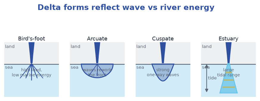
Where the river meets the sea it faces a competitor. If the river arrives with a large sediment load into a sheltered, low-energy coast, it drops that load faster than waves can remove it, and a delta builds seaward. If tides and waves are strong, they win: they disperse the sediment, scour the mouth, and the river enters the sea through a drowned, funnel-shaped estuary instead, where fresh and salt water mix in a wedge that varies with the tide. The contrast is a balance of three things — the river's sediment load, the wave energy of the coast, and the tidal range. Where all three are moderate the mouth is a hybrid, part delta and part estuary, and it can swing from one behaviour to the other as the balance shifts.
Estuaries are not merely failed deltas; they are distinctive environments in their own right. In a salt-wedge estuary, where the tidal range is small and the river flow is strong, the denser salt water creeps along the bed as a wedge beneath the fresh water, moving landward as the tide rises and retreating as it falls. Where the tide is powerful and the water thoroughly stirred, the fresh and salt water mix completely and the estuary becomes brackish throughout. The type depends on the same trio of forces — river flow, wave energy, tidal range — that decide whether a delta forms at all, so the shape of a river mouth is a compact summary of the balance between the river and the sea.
Delta shape records which force dominates. The classic classification follows the three end-members. A bird's-foot delta forms where the river's load is huge and marine energy is low, so distributaries push long fingers of land straight out to sea (the classic Mississippi pattern). An arcuate delta is fan- or tongue-shaped, where waves rework the deposited silt into smooth curved fronts (the Nile is the textbook example). A cuspate delta is pointed and tied to the coast, built where strong, consistent waves sweep sediment into a narrow protrusion (the Ebro shows this form). Where tides are very strong, the "delta" is really a tidal estuary with sandy tidal flats rather than a prograding lobe. Because the three controls can shift over geological time, one river may pass through several of these forms as sea level, sediment supply, and wave climate change.
Deltas also rebuild themselves. When one lobe silts up and chokes its own distributary, the river avulses — it breaks to a new path — so a mature delta is a stack of abandoned lobes. Because a delta is built at the coast, often on soft, compacting sediment, it tends to subside under its own weight and the weight of the sediment piling up around it. Subsidence lowers the surface, and unless fresh sediment replaces what is lost, the delta can drown — the sea reoccupies land the river once built. This is why a dam that traps sediment far upstream can starve a delta even though the river itself is unchanged: the delta is deprived of the very supply that kept it above water. A delta is therefore a running balance, not a permanent feature: it survives only as long as the river keeps feeding it material faster than the sea removes it and the ground sinks.
A delta grows seaward by progradation: each flood delivers a fresh layer of sediment to the front of the delta, and the shoreline advances a little further into the sea. Over many floods the delta builds upward and outward at the same time, laying down the gently sloping beds that geologists read as the record of an advancing coast. But progradation continues only while supply exceeds loss. If the sediment supply is cut off — by a dam upstream, or by a change in land use that reduces erosion — the delta stops advancing and begins to retreat, because waves and tides keep working on its front while nothing replaces what they remove. This is why the fate of a delta is decided far upstream, in the catchment that supplies its sediment, as much as at the coast where it is built.
6. Drainage Patterns
Viewed from above, a river network is not random — its geometry is a fingerprint of the rocks beneath. A drainage pattern is the plan-view arrangement of streams, and each common type betrays a different geology. The reasoning behind this is simple: water always seeks the easiest route downhill, and what counts as "easiest" depends on the rock. Where the rock is uniform in all directions, water spreads evenly and the network branches like a tree; where the rock is banded, broken, or domed, the water follows those structures and the network takes on a matching shape. Reading a drainage pattern is therefore a way of reading the geology of a region from the air, before a single sample is taken.
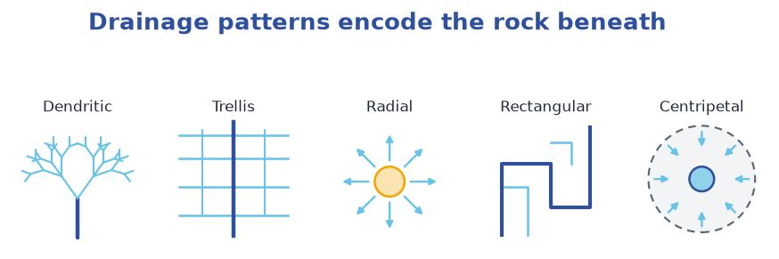
The dendritic pattern looks like the branching of a tree. It forms where the bedrock is uniform — equally resistant in all directions, with no strong folding, faulting, or preferred joint direction. Because there is no structural control, tributaries take the path of steepest descent and join at whatever angle the slope allows. Most basins are at least partly dendritic, and it is the default pattern where nothing else interferes.
A trellis pattern has a main stream running along a weak valley, with tributaries entering at near-right angles from parallel ridges. It forms in folded terrain where hard and soft rock layers alternate: the soft layers erode into valleys that the streams follow, and the hard layers stand as ridges that force tributaries to meet the master stream almost perpendicularly. The result looks like a garden trellis, with the long parallel lines of the fold ridges crossed by the short, straight tributaries.
A radial pattern spreads outward in all directions from a central high point — a volcano, a dome, or a raised plateau — because water simply runs off the summit down every slope. It is the pattern of a mountain built up from a point, and it announces that a single elevated structure sits at the centre.
A rectangular pattern looks grid-like, with sharp right-angle bends. It develops where the rock is cut by two sets of joints or faults at right angles; streams exploit the cracks and turn only where the fractures do, ignoring the local slope. A rectangular pattern is a strong clue that the bedrock is fractured rather than uniform, because the water is following the cracks instead of the general downhill direction.
A centripetal (or inward) pattern drains toward a central depression — a crater, a closed basin, or an inland playa — because there is no outlet to the sea. Its mirror image is the radial pattern: instead of spreading out from a high point, the streams gather in toward a low one. In glaciated landscapes a deranged (disordered) pattern appears, with lakes and rambling channels that ignore any obvious structure because ice scour erased the pre-glacial drainage. Where soluble limestone dominates, the surface network may be sparse or chaotic because the water goes underground, through caves and sinkholes, rather than following surface channels at all.
The practical lesson: the map of a river system is a geological map in disguise. A trellis announces folded rock; a radial announces a volcano; a rectangular announces a cracked, fractured bedrock; a centripetal announces a closed basin with no outlet. Joints deserve special notice: even in otherwise uniform rock, a single dominant joint set can bend streams along it, so pattern is as much about cracks as about whole rock types. Drainage density — the total length of channel per unit area of basin — is itself a clue: a dense network of closely spaced channels implies impermeable rock or steep slopes that shed water quickly, while a sparse network with long, widely spaced channels implies permeable rock that swallows rainfall before it can organise into streams.
7. Rivers as Resource and Risk
A river is both a utility and a hazard, and the two faces are inseparable: the same channel that supplies water and carries away waste is the one that floods the land and drowns the crops. Learning to live with a river means managing both faces at once, and every engineering fix aimed at one tends to change the other.
As a resource it supplies most of the fresh water humans use — for drinking, irrigation, and industry — and its predictable lowlands invite settlement. Where the gradient is steep, a dam converts the river's potential energy into electricity: water held in a reservoir drives turbines, and the stored volume smooths the natural regime, releasing water in dry months and holding it back in wet ones. The same reservoirs support navigation, fisheries, and a buffer against drought. The trade is that a dam catches the river's load: the reservoir silts, and the reach below is starved of the sediment that once built its banks and delta. A reservoir is, in effect, a sediment trap built across a river, and like any trap it fills up; over decades its storage capacity — and its usefulness — declines.
As a risk, the river is the flood. A flood occurs when discharge exceeds the channel's capacity and water spreads across the floodplain. The trigger is almost always a surge in runoff — intense rain, rapid snowmelt, or a storm surge — but the damage is shaped by the land: bare or compacted ground generates more quickflow, deforestation removes interception and infiltration, and paved cities send rain straight to the channel. A basin that has been hardened and cleared floods harder and sooner. Because the same changes that make a flood worse are the ones that come with development, flood risk tends to rise quietly in step with the growth of towns and the clearing of forest, even where the rainfall itself has not changed.
The way a basin is used can turn a moderate storm into a serious flood. When forest is cleared, the roots that once opened the soil and slowed the water are gone, so more rain runs off the surface and less soaks in. When fields are compacted by machinery or grazing, their surface seals and infiltration falls. When roads, roofs, and paving cover the ground, water that used to soak away is delivered almost instantly to the nearest drain and then to the river. Each step moves the hydrograph toward a shorter lag and a higher, sharper peak, so a storm that would once have passed harmlessly now arrives in the channel all at once.
A dam changes the regime but creates new problems. By trapping sediment in the reservoir, it starves the reach below: the river arrives hungry, erodes its bed and banks, and — at the coast — fails to replenish its delta, which then retreats. The reservoir itself silts up, slowly losing capacity. Levees that wall a river in protect the adjacent land but confine the flood to a narrower space, raising the water level and the speed; the flood is not prevented, only shifted downstream and made more violent when it does break out. The lesson repeats across basins: engineering that speeds water away in one place deepens the problem in the next. A river walled in by levees behaves like a pipe, and when the pipe is breached the flood that escapes is deeper and faster than any natural flood would have been, because the same volume of water is confined to a smaller cross-section.
Water quality is a separate axis. Point-source pollution enters at one identifiable place — a sewage outfall or a factory pipe — and is comparatively easy to regulate and treat. Non-point-source pollution arrives diffuse from the whole basin: fertiliser and manure wash from fields as nitrates and phosphates, feeding algal blooms and eutrophication that strip oxygen from slow reaches and kill fish. Because non-point pollution has no single pipe to close, it is harder to control than point-source pollution, and it scales with how the entire catchment is farmed. The difficulty is one of accountability rather than of chemistry: a factory can be measured and made to treat its discharge, but a thousand fields each contributing a little nutrient are far harder to police, even though their combined effect can be larger.
The mechanism of eutrophication is worth following because it shows how a nutrient surplus becomes an oxygen crisis. Fertiliser washed from fields adds nitrates and phosphates to the water, and these are the very nutrients that plants need. In a slow-moving reach the added nutrients feed a rapid bloom of algae. When the algae die, they sink and are decomposed by bacteria, and that decomposition consumes oxygen from the water. Where the water is stagnant and cannot be re-aerated by the atmosphere, the oxygen is stripped out, and fish and other animals that need it suffocate. The pollution is not toxic in itself; it kills by over-feeding the system until the oxygen runs out.
The modern response is often restoration — not only concrete defence but giving the river room to work. Removing obsolete dams reopens migration routes for fish, restoring access to the spawning grounds that the dam blocked. Reconnecting the floodplain lets fields store flood water in winter and grow hay in summer, turning the floodplain back into the sponge it was before it was walled off. Rebuilding meanders (renaturation) trades a straight, fast channel for a slower, more diverse one that holds water longer and shelters wildlife. These measures work in the same direction: they slow the water, spread it out, and let the river deposit its sediment where it naturally would, rather than forcing it downstream as fast as possible.
Engineers describe river management as either hard or soft. Hard engineering builds structures to resist the river: concrete walls, embankments, dams, and straightened channels. It works quickly and predictably, but it is expensive, it needs constant maintenance, and it tends to pass the problem downstream rather than remove it. Soft engineering works with the river instead: restoring meanders, reconnecting the floodplain, planting bankside vegetation, and setting land aside to flood. It is slower and less certain, and it needs space that developed land often lacks, but it addresses the cause of the flood rather than its symptom. The two are often combined, with hard defences protecting the most valuable land and soft measures elsewhere. The choice between them is really a judgement about what a society values: the certainty of a wall against the cost of maintaining it, versus the uncertainty of a natural floodplain against the benefits it brings.
The lesson of the whole system is that a river managed only as a conduit — move the water away fastest — eventually breaks the banks it was meant to protect. A river allowed to spread, slow, and deposit is a river that floods less destructively and lives longer.